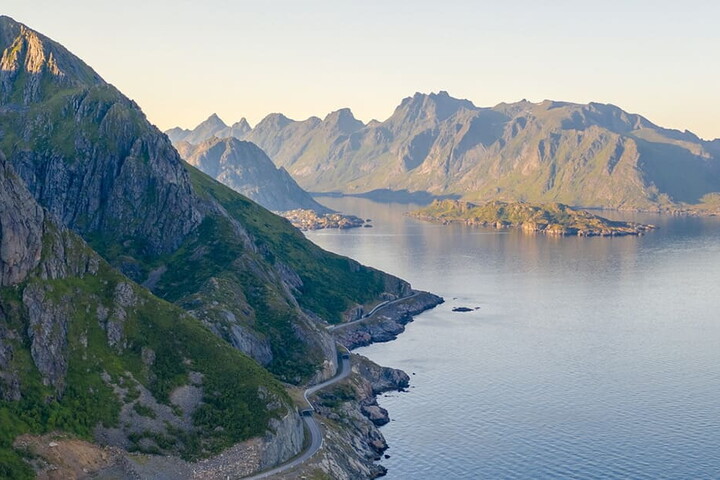
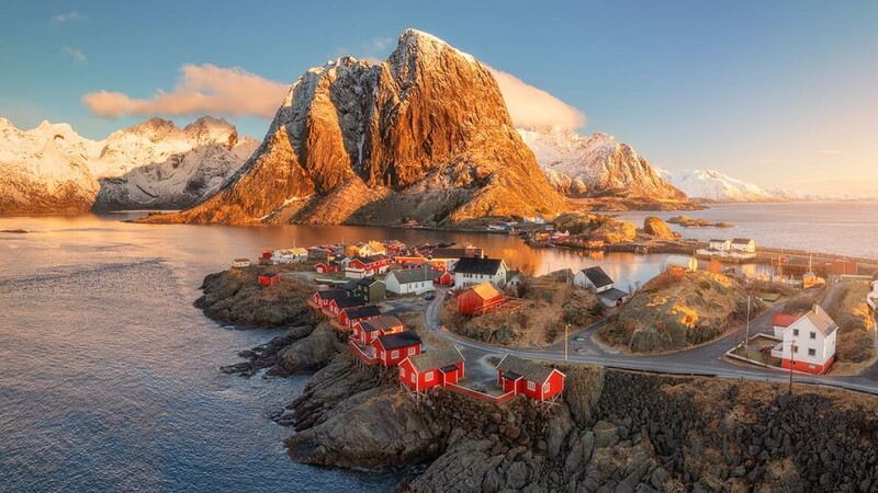
The E10 is the Northernmost road in Europe, stretching for a total of 850 kilometres to connect Sweden with Norway. In its Norwegian segment, it is also known as Kong Olav Vs vei (King Olav V's Way), named after the historic and beloved monarch who ruled the country from 1957 to 1991. This is no small tribute; the 397 kilometres on Norwegian soil are among the most evocative in terms of natural beauty, linking the mainland to the Lofoten Islands. Indeed, it is precisely as you cross the elegant Raftsundet Bridge, attempting to reach the Southern tip of this archipelago and the picturesque fishing village of Å, that you realise why this section - known as the Lofoten Scenic Route - is so cherished by travellers and locals alike. It is not merely a transit route, but a gallery showcasing the very best that Norway has to offer in terms of culture, hospitality and nature. As you clock up the kilometres and decide to stop in one of the villages along the way, it becomes clear how humanity and such a wild territory have found a way to coexist, basing their survival on mutual respect. Thanks to its characteristics, the route is part of the Norwegian Scenic Routes which, as the name suggests, comprises a collection of roads curated to showcase the splendour of the Norwegian landscape. Take Svolvær, for instance: the capital of the archipelago, nestled among several islets and dominated by Svolværgeita, a rocky pinnacle over 150 metres high that keeps watch over the city. Or Henningsvær, dubbed the "Venice of the North" because, much like its Italian counterpart, it possesses a unique urban layout. It is a village situated in the middle of an archipelago of islets linked by bridges and breakwaters. Despite its small size, it hosts numerous art galleries, attracting enthusiasts and connoisseurs from across Europe.
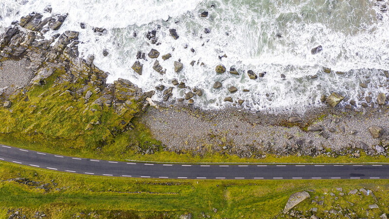
Drivers embarking on this journey know that while the distance is not excessive, the driving experience is intense. The carriageways are extremely narrow; when encountering a heavy vehicle from the opposite direction, proceeding requires the ability to calculate your space to the nearest centimetre. Numerous bridges must be crossed and weather conditions are a vital factor to consider, especially if you decide to travel in autumn or winter. During these seasons, roads are often covered in snow and grit (the use of studded tyres is mandatory between October and April). Phenomena such as black ice and side wind gusts exceeding 25 m/s can be highly dangerous and demand absolute focus. Summer, conversely, is the best time to take advantage of milder temperatures and the legendary midnight sun, though overtourism can significantly slow down travel and make stops feel crowded, far from the tranquil ideal many seek in Lofoten. Nevertheless, this route offers sections that are firm favourites among motorists, such as the Fredvang bridges. Opened in 1988, these two cantilever bridges feature a striking curved design that follows the marine topography. This creates the sensation of driving while floating over the turquoise waters of Kvalvika beach. Then there is the descent towards Nusfjord, a winding, panoramic road snaking between rock faces and sudden glimpses of the sea - and the stretch from Reine to Å, perhaps the most technical section, requiring great precision of manoeuvre due to the particularly narrow road widths.
For those looking to enjoy the drive while discovering Norway's most characteristic corners, several world-famous villages provide perfect stops. On the outer coast lies Eggum, where a natural amphitheatre - carved from an old quarry and the ruins of a Second World War radar station - provides a magnificent vantage point of the midnight sun. Reaching the Southernmost part of the islands, after passing the white sands of Ramberg and taking the aforementioned road to Å, you can choose to stop first in Reine. This village is home to the iconic red rorbuer (traditional fishermen's cabins) that reflect in the fjord waters under the shadow of the Reinebringen Peak. The journey culminates in Å, a living open-air museum dedicated to the history of stockfish.
Norway is deeply committed to climate action and is adopting a series of policies to protect the archipelago from mass tourism and atmospheric pollution, with the ambitious goal of reaching zero emissions by 2030. Consequently, travelling the Lofoten Scenic Route also means respecting this vision. Priority should be given to low-emission or electric vehicles (the archipelago is well-equipped with charging stations) or visiting during off-peak periods (although the local government already has a careful policy for managing tourist flows) to ensure that these fragile ecosystems are not placed under further pressure. Travelling along this road today therefore means becoming ambassadors for slow, respectful tourism where the pleasure of driving meets the contemplation of a landscape that is unlike any other in the world.