The road to the Stelvio was founded in 1820 to connect Milan (in the Kingdom of Lombardy-Veneto at the time) with Vienna (in the Austrian Empire) without having to travel through Switzerland; it is a road built for commercial and military purposes. Its construction was entrusted to the engineer Carlo Donegani, based on a Napoleonic draft that he modified in depth with innovative solutions: a 5-metre wide road; a slope that never exceeded 10%; 42 hairpin bends on the Valtellina side, 48 on the Alto Adige side; tunnels dug out from the rock or in masonry with wooden snow sheds.
An extraordinary masterpiece, for the time, built in just 5 years with design and construction solutions that stand out for their originality and beauty, features that still make travelling along it bewitching every time.
It has been the site of historical events for Italy, in the military and cycling worlds, and today the road is one of the busiest tourist routes in the Stelvio Park, both for its exceptional scenic aspects and for its sporting value. Today we are talking about it from this perspective in fact: tackling the Stelvio Pass, at 2,758 m above sea level, is one of the most fascinating and challenging road bike routes.
In addition to the altitude (it is the highest pass in Italy, the second in Europe), which makes the air rarefied and often icy, it is protected from climbs by the generous gradient, which isn't extreme but is relentless in length, a characteristic that requires concentration and serious training.

Three roads to the summit
The summit can be reached by climbing three routes: from Prato allo Stelvio, from Bormio or from Santa Maria Val Monastero. Cyclists tend to prefer the two roads on the Italian side, so setting off from Bormio or Prato, a route which we have already discussed in the following article:
This time, we're taking the climb from Bormio, with its open and panoramic landscape. It is a little easier in some ways, at least in terms of numbers: the road is shorter, stretching just over 21 km (compared to about 25 km from Prato) and the difference in altitude is 1,533 m (1,851 m from Prato), but the climb has two sections with steeper slopes. Although you have to tackle “just” 42 hairpin bends, against the 48 on the climb from Prato, but the challenge is the same: to get to the top, you still need a generous supply of leg work, heart rate and lung capacity. Now that we know what lies ahead, let's get on our bikes and start off from Bormio.
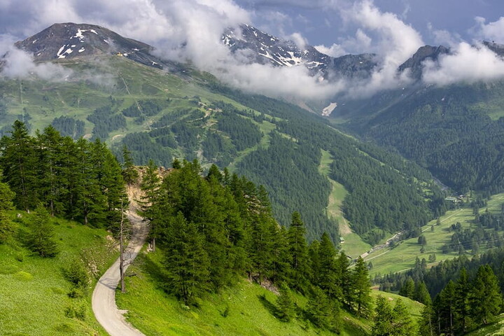
The climb from Bormio
Bormio is one of the most beautiful ski areas in Europe, at an altitude of 1,225 m with an elegant old town in perfect Alpine style, with its typical cafés, narrow alleys and ancient portals. Thanks to the naturally flowing hot water springs, relaxing here is easy, spending a day at the spa after a hard day's cycling can be a great idea; however, it may be risky to try them before you set off as they may be a little too relaxing given the climb ahead.
The slope from Bormio offers a fantastic scenery amid pine forests and endless expanses of space, and the route is distinguished by its long ramps and varied landscapes. The climb is divided into three parts: before the tunnels, the plateau, and the last stretch after customs. In the first and last part, the slopes tend to be steeper, with peaks averaging over 9% and a peak gradient of 13-14%.
The climb traditionally begins at the junction between the Gavia and Stelvio roads, at the gates of the historic town centre, coming across the first hairpin bend after about 900 metres, and shortly before the 3 km marker, the climb stabilises at a gradient of around 7-8%. After entering the National Park, you cross a ravine and enter the tunnel referred to as dei Bagni, carved into the living rock. In this stretch the road cuts through the rocky wall rising on the right bank of the Braulio, and the milder slope allows you to recuperate your energy. What's more, the view opens up to an extraordinary sight.
You come across a very demanding stretch along kilometres 10 and 11, with the gradient mostly reaching double digits, but once you have reached the approximate altitude of 2,000 metres, after about 14 kilometres, you reach Bocca del Braulio, with 3 kilometres of gentler slopes (4-5%) so you can recover a little. The route continues until you can finally glimpse your goal, about 400 metre ups higher, but you will need to gather your last resources as you approach it, to tackle the slopes with a steeper gradient once more (9-9.5%). This leads to kilometre 21.5 where the Pass finally opens.

Fit and focused
Both from Bormio and Prato, the Stelvio climb is an uphill battle. The route is not very long but the slopes show no signs of letting up and the difference in altitude is high, which in addition to engaging your leg muscles also tests your respiratory system, since the air density decreases at an altitude of over 2,000 m. So it is a good idea to tackle the climb properly trained and with plenty of experience in long climbs; in addition, you have to think about the climb in terms of time, not length, and you have to ask yourself if you can endure the strain of pedalling for as long as it takes to reach the summit. How long it takes to get to the top obviously depends on how fit you are, and if you are well prepared, it could take you approximately 1 and a half hours to 2 hours.
Can you calculate how long it will take you to climb? Of course. A reliable data, if the calculation has been performed correctly, can be obtained from the VAM (Mean Ascent Velocity). It expresses, in metres per hour, the personal uphill potential and represents your fitness level. For example, a VAM of 1000 m/h allows you to climb the Bormio side in just over an hour and a half, which is a very good performance. Your VAM can be calculated automatically with a dedicated cycling App, or using the simple formula: (elevation gain x 60) / time in minutes. In this case, it is advisable to consider several climbs, in order to assess the number more precisely, and in the case of the Stelvio it is also advisable to take into account a certain margin of safety, considering the altitude reached.
It is advisable to plan the climb at a warmer time of the year, since you reach a high altitude; always carry heavy clothing (the weather can change quickly) and leave in the early hours of weekdays, to avoid the intense tourist traffic.
Riding in honour of the Champion
The Stelvio Pass also adds the charm of history to everything we have explained so far. Cycling up the glorious climbs, you will experience the thrill of the races, which began in the 1953 Giro d'Italia. It was here that Fausto Coppi gave us one of his most epic wins, by attacking the race leader Hugo Koblet, gaining a lead of three and a half minutes and winning the pink jersey, thus making the Stelvio a place of courage, drama and triumph. This is why today it is called Cima Coppi, a name coined in 1965 in honour of the Top Champion by the director of the Giro d'Italia Vincenzo Torriani. Since then, many other decisive and controversial moments have taken place on these slopes, consolidating this cycling icon gem of the Eastern Alps.